Showing posts with label Misc. Show all posts

Thursday, April 16, 2009

Nostalgia Cach

Wow, it's been a while since I posted anything. Where has time gone....

I stopped by one of my caches this morning, Up Front (we'll, I really stopped to find a new cache but since I was in the area I decided to checkup on this cache too.)

Based on some of the previous logs I decided I better check on the cache because it appears people are finding more than one cache.

I found my cache quickly (knowing where it was) and everything was just fine. But the real goal of the maintenance run was to find a possible second cache in the area. It took some time but I finally found it about 30-35 feet from my cache. Looks like three other cachers were also lucky enough to have found it in the last little while.

The cache was intact for the most part. Small chew holes on the lid let water leak in but the log book was dry in its baggy.

Interestingly, according to the log book cache was placed in Dec 2002. It was found 5 times before going dormant in Jan 2003. The finders were Kleiner, Jonsom, Eron?, EelSid, and lastly, lsildvr's Bane on Jan 11, 2003.

The cache has been hidden well since then - at least well enough not to be found by anyone.

I searched GC.COM to try and find the old cache and came up with this...

The old cache was called "Cuddle Up" by Centris.
I know the coords were at the dome but Cuddle Up is a puzzle cache and looking through the logs and the pictures the puzzle definitely led them to this cache location (there's a picture of the old cache in a log by Centris - and that's what I found, today).

I removed the old cache and contacted Centris so she could also benefit from a little bit of nostalgia.

Thursday, November 20, 2008

Geocoding addresses and loading them into your GPS

What does "geocode" mean and now is it going to help me? Geocoding is the process of converting an address (like 123 1st St) into a set of coordinates (expressed in Latitude and Longitude). I suppose that's not really correct, though. There is no "conversion" going on. Goecoding really finds a set of coordinates for a given address. In my testing I found it to be fairly accurate - at least close enough for me to get where I need to go.

How it will help you depends on what you're trying to accomplish. In my case, I work with the youth group at my church. Sometimes I provide rides to or from various activities and have to pick them up or take them home. I know these kids and their families very well, but that doesn't mean that I know how to get to all of their homes. I also don't know their addresses off the top of my head so just typing their address into the GPS isn't always an option, either.

So with the problem in mind I set out to find a solution. This article describes what I found.

As I thought about the problem I came up with a basic set of steps that I thought I would need to do.

1. Get the address data I needed
2. Format the data into proper format - whatever that meant
3. Geocode the addresses
4. Create a GPX file to load into the GPS.

Seemed pretty simple, I guess. At first I thought it would be fun to break out the coding skills and write something that did this for me. However, after a few hours with Google, testing a few things, and throwing some things away, I put my coding skills back on the shelf and came up with a fairly straight forward process for "Geocoding addresses and loading them into your GPS."

I tested the process with the Garmin line of GPS's. I tried it with a Garmin Nuvi 660, eTrex Vista HCx, GPSMap 76 CSX, and other eTrex units. I didn't have access to other brands to test but assuming they can deal with GPX files this should work just fine.

Once you've created the GPX file you can either load it onto your GPS as waypoints or you could even load it as points of interest. Points of interest act differently than waypoints so feel free to experiment with it until you get a format that you like. For this article I'm going to load the data as waypoints.

You should also take into account how may waypoints and/or points of interest your GPS can handle. In the Garmin line there are some that can handle 500 waypoints while others can have 1000 or more. Just make sure you consider how many you have and how many you're going to try and load.


1. Get your list of addresses - electronically of course unless you like typing.

2. Format the list into columns with the following structure (Excel works well). Make sure the first line is a column heading. You can use the example below to get it started.

Address City State Zipcode Name Description Symbol

Address = The street address of the person. "2400 Pennsylvania Ave"
City = The city. Try and be specific. "Coon Rapids"
State = The 2 letter abbreviation for the state: "MN"
Zipcode = The 5 digit US zip code "55432"
Name = The name of the waypoint you want in your GPS. I like the families last name for this. Keep in mind your GPS limitations on the length of a waypoint name. You'll also want to make each name is unique. Think about this one - don't just jump in with any old name.
Description = This will show up in the waypoint "comments" in the GPS. Keep in mind the max length your GPS will take. It will usually truncate it for you but you never know.
Symbol = The name of the icon you want to use in your GPS.

Here's an example of what it might look like (the lines may wrap)

Address,City,State,Zipcode,Name,Description,Symbol
123 1st St,Landen,MN,82520,Macfarlane,123 1st St 952-555-1212,Residence

You can see that I also decided to add the phone number to the Description field. That way I'll have their address and phone number in the GPS if I ever need it. Be creative and try various things with the name and description. You can't break it and anything you add can always be removed if you don't like it.

Here's a hint while you're testing... In the example above I used "Residence" as the Symbol (GPS Icon). The Garmin line of GPS units allow you to delete waypoints by symbol. So, if you use a unique symbol, say something like "Diver Down Flag 2" you can easily delete all the waypoints you just added by removing only the "Diver Down Flag 2" symbol. This will allow you load and delete the data as many times as you want without harming any of the existing data on your device.

Same logic should be applied to Points of Interest. Make sure you use a separate POI file just for these addresses. That way you can easily reload your other POI files if needed. I'm not going to go into details about POI files for the Garmin units but you can find ton's of information by Google'ing "Garmin POI"

3. Assuming you used Excel in step 2, save the file as a CSV file. If you didn't use Excel and just used a text editor, that's fine, too.

4. Open the CSV file in a text editor (wordpad or notepad) - NOT Excel!

5. Highlight all of the text. Press CTRL-A for a quick way to highlight all.

6. Press CTRL-C to copy it to the clipboard. You can also choose File | Copy from the menu on most text editors.

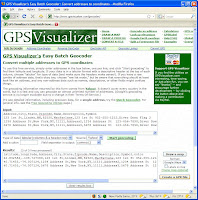
7. Open a web browser and go to the following URL http://www.gpsvisualizer.com/geocoder/
This web site is going to do the rest of the work for you. You can read all about what it's doing by visiting the web site.

8. Click in the white box labeled "Input" part way down the page.

9. Press CTRL-P to paste the address you created earlier into the "Input" box. You should see all of your address in the box. If nothing showed up, go back to step 4 and try again.

10. In the "Type of data:" dropdown box, select "Tabular (columns & a header row)"

11. Press the green "Start Geocoding" button to the right.
It will read the addresses in the "Input" box, lookup the latitude and longitude of the address, then create a set of formatted data in the "Results" box located below the input box.

12. If you want to keep the latitude and longitude data around for some reason you can copy can paste it into a new text file. I don't save this data. It can always be obtained again if needed.

13. Just to the right of the "Results" box is a button labeled "Create a GPX file" Press the button to create a GPX with all of your address in it.

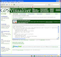
14. Once the "Create a GPX file" button is pressed, it will create the GPX and open a new web (depending on the number of address you converting it may take a little longer). At the top of the page you can download the GPX file. In the middle you'll find the contents of the GPX that you can cut and past if you wish. Save the GPX file to your computer.

----- Note: From here you should check with your GPS documentation to see how to load data from a GPX file. The following steps will describe one way to load waypoints to a Garmin GPS by using the Garmin Mapsource software.

15. Start Mapsource and open the GPX file you saved.
You should be able to see all the waypoints for the addresses you used on the web site. You should also see the correct symbol/icon you used (eg "Diver Down Flag 2")

16. To send them to your GPS as waypints:
a: Connect your GPS to your computer and turn on the GPS
b: Select "Transfer | Send to Device" from the Mapsource menu.
c: Select Waypoints under the What to Send section.
d: Press the Send button to send the data to your device.

That's it. You now have all your friends loaded as waypoints on your GPS. Assuming your GPS has turn-by-turn navigation, you can now easily navigate to a an address by searching for the waypoint.

Questions and comments are always welcomed!

Note: I am not affiliated with GPSVisualizer in any way. They control the web site and may change it. In order to support the development of free tools like GSPVisualizer, feel free to contribute to them by using the links on their web page.

Thursday, September 18, 2008

Ring Ring goes the Geocache

I know cachers are a friendly bunch and I've seen it in action before. But these log entries from one of my recent hides takes the cake. Not only does it prove that people generally want to do the right thing but it shows what a little bit of luck can do....


Cache: What's your sign? (GC1GCGJ)

September 18 by notsmike (1581 found)
Looking for this cache, I dropped (lost) my cell phone.Not knowing where I misplaced it I called it to see if I could locate it. XHawk was looking for the cache and heard the ring, answered it and waited for me to come back and pick it up. Very nice meeting you XHawk and thanks again.notsmike [view this log on a separate page]

September 18 by XHawk (714 found)
I usually stink at puzzles. So I was real happy to solve this one. Doubled back to the car to put on long pants. A good idea on this one. Found cache right after hearing a phone ring. After signing log, I hung out and waited for notsmike to show. Nice meeting you today. TFTPC![view this log on a separate page]

Is that cool or what??

Monday, September 8, 2008

27 Mile Bike Ride

It's been a long time since I've written anything here. There is so much to write about - lots of caches, vacation caching, etc, etc - and the more I think about it the more it seems like an argues task. So to compensate, I've just put off writing anything. Well, that has to stop - now. So I'm going to have to just skip the fun, exciting stuff I haven't written about and move on.....

This weekend EagleEyeMN (my oldest son) and I went for a bike ride around Forest Lake (both the town and the lake). Our goal was to make it a 25 mile ride - it ended up being a little over 27 miles in the end. Of course I planned a series of caches to do along the way, too. Finally tally was 19 finds, 0 DNF's, 1 we decided we couldn't get to, and 2 that we skipped because they haven't been found for so long (and we had to keep moving).

We parked the car at Tolzmann Park at the north end of the lake, got the bikes and the packs ready and headed out counter-clockwise around the lake. Our first cache was about 400 feet away - whew, that's was a tough ride :-)

Our second stop was disappointing - and gave us thoughts of not being able to complete both tasks - 25 miles AND all the caches we have on our list. The cache just didn't seem to be accessible from where we were and if we wanted to go around to get it we'd spend too much time. So we decided to skip it and keep going.

The next part of the ride was filled with caches. Of course some of them were very quick - either EagleEyeMN or I would spot them and be picking up the cache before the other one even got off their bike. Those type of caches helped us stay on time (although the only time commitment was that we had to be done in 8 hours - not too difficult).

At about the 7 mile mark we started looking for The Treasure Hunt (GC1FV3J). This was a fun multi stage cache. The cache hider, Plumcitykitties, did an outstanding job with both stages of this cache. They spent time in ensuring that both containers were unique and fun. Thanks for all the work, guys! You'll have to go find the cache yourself to see what I'm talking about.

Next we headed back toward the lake and decided to stop for lunch at Beltz Park and X-Ray (GC1CXG0). Another excellent cache hide by Plumbcitykitties! The park was hopping with kids and a couple of adults so the fact that we were stopping for lunch made it a little easier to grab the cache. Luckily, EagleEyeMN put is eagle eyes to work and found the cache right away. However, it took some time before we could actually retrieve it. When the time was right we made the grab and got it back quickly. Thanks for another great hide, guys!!

After eating and grabbing the cache it was time to move on. We skipped one on the way to Hardwood Creek WMA (GC59A2) because it hadn't been found in a long time - and the fact there there were two cars and a handful of muggles at ground zero when we passed by. We did, however, stop and take a quick 2 minute break there anyway.

Hardwood Creek WMA was interesting. You can read the log to get some more information. Needless to say we were lucky to get out of there without getting poison ivy.

By this time in the ride we were both tired but still feeling pretty good. We made it about 16 miles and were at the south end of the lake. Only 5 caches left to go on our list.

We headed up the east side of the lake and took another break at the next cache - North Shore Trail (GC1709T). Fun hide - mostly because of the muggle traffic. We were lucky today, though. The muggles were already out on the lake and not coming back in yet.

Status check.... EagleEyeMN is doing just fine and I'm starting to get tired. I'm not hurting yet but that last couple of miles were a lot more difficult for me than for him. Finding the cache - and grabbing a candy bar - gave me a few minutes to recover before heading on.

As we continued to head up the east side of the lake, we decided to skip the next cache because it hadn't been found in a while and we needed to keep pressing on. Thinking back on it now I should have stopped and taken another break - but we didn't.

Last stop for the day was Kulenkamp Memorial Park with 4 caches in the park. Although mostly uneventful in this park there was one multi cache - Sudsy (GC16ZPJ) - that needed some help. Checkout the log for more details. The other interesting cache in this park was Kavanaugh Red (GC1CMJH). Seems some soon-to-be hunters wanted a deer stand in the park. I don't know if hunting is legal in that park but there's a deer stand at ground zero now (see my log).

We now have all of our caches done and it's about a 3 1/2 mile bike ride back to Tolzmann Park and the car. We're both tired but getting the caches in this park gave us time to recuperate. So off we went.

We finally arrived back at the car. EagleEyeMN was tired but still feeling "ok." I, on the other had, was about to DIE!! The last two miles of the ride really did me in. We didn't stop since leaving Kulenkamp park. It was only 3 1/2 miles but it really did me in. My quads were about to explode! I did all I could do to get off my bike and walk over to a bench to sit down for a rest. EagleEyeMN graciously took the time to pack up the bikes while I just watched from a distance (thanks, dude!).

Overall it was a fun day. EagleEyeMN and I were able to spend some good time together and he was able to prove his young legs were much better than my old legs. That's ok, though, I can still do more push ups than he can :-)

Monday, June 23, 2008

KB Challenge - Minnesota Bakers Dozen

Last week I spent all of my caching time working on the King Boreas Minnesota Baker's Dozen challenge cache. I've written about this challenge before so you've probably heard about it, but the essence of the challenge is to find 1 cache on day 1, 2 caches on day 2, 3 caches on day 3, all the way to 13 caches on day 13. Now the day's don't have to be consecutive days or that would be impossible for me to complete - I don't cache 13 day's in a row. The other major rule is that at least one of the caches found on a particular day must be either a multi-cache or a puzzle cache. That throws an interesting twist into the whole thing. Visit the cache page for more details.

So last week I found myself ignoring the coveted FTF's just because I've either already hit my number for the day, or the FTF might be a multi or a puzzle and I can't go get it because I already have my multi or puzzle for the day. So I passed on a couple of FTF hunts.

However, last week I was able to complete some of the bigger number day's. Here's my cache bookmark which shows my progress so far. I focused on the bigger number days on the weekends because it's almost impossible to get 12 or 13 caches at lunch. I used to be able to do it but now I have to drive too far because I've cleared out the area close to work. Now just getting 3 or 4 caches takes up the lunch time (and sometimes I'm only able to get 1 or 2).

The progress last week looks something like this:
  • Sat June 14 - Day 13 - Tbone and I did this. Another post talked about our adventures on our bikes.
  • Mon June 16 - Day 4
  • Tue June 17 - Day 7 - This required a longer lunch, though.
  • Wed June 18 - Day 2 - The multi I did here was a killer. Took way too long - but fun!!
  • Fri June 20 - Day 12 - I was at a baseball tourney and was able to get enough caching in between games to get the full 12 done.
  • Sat June 21 - none - I had high hopes of getting day 11 out of the way - but there was no time between baseball games today.

So overall it was a successful week - getting Day 12 and 13 out of the way. Only 4 days left, 5, 9, 10, and 11. I'm afraid it will take a couple of weekends to get 9, 10, and 11 out of the way, though.

Saturday, May 10, 2008

Free Maps for Garmin units

I haven't had much time for caching the past week. Work has me hopping right now. It will slow back down in a week or two - then they'll be more time for caching again.

I have spent some time looking at maps for my Garmin units that I don't have maps for. I found some excellent maps (most are works in progress).

First Topo Maps from http://www.miscjunk.org/mj/mp_main.html.
They cover Wyoming, Utah, Montana, and Colorado and they are great! I took an older eTrex Legend (old blue - with only 8meg for maps) and loaded some of the Wyoming maps. I choose Wyoming because I grew up there and thought I would know if the maps were accurate or not. Well, the they are exceptional! The contours are excellent, plus you get street maps for cities and towns!! Next time we go out there I'll definitely load the older GPS's with these maps. The kids will love it compared to not having any maps at all.

They also have some off road maps for Minnesota. You Minnesotans might want to check them out.

My second great find was http://www.gpsfiledepot.com/.
Although the map choices are sparse, they have "How To's" to teach you how to create your own maps. I thought this was pretty good, and if I find the time, I might just try it myself.

Next it was off to http://openstreetmap.org/.
A very interesting community based project. These guy's are mapping the world one saved track at a time. Take a look at your area and I bet you'll be impressed. What I found most useful about this site was the European maps that can be generated. If you're planning a trip over seas, take a look here and learn how to make your maps before you go.

Lastly, follow this topic in the GroundSpeak Forums http://forums.groundspeak.com/GC/index.php?showtopic=189762.
These are the best street maps I could find (for free!!). ibycus is doing an outstanding job creating a complete USA map set. If you haven't seen this yet, it's a "must see." The only issue that I could find is the speed of the GPS. I tried loading a set of maps on the old eTrex Legend. They load just fine. However, the blue eTrex Legend just isn't powerful enough to draw the maps quick enough. It took forever because of all of the detail ibycus is providing. However, on the newer color eTrex line it worked great.

So, if you're looking for maps and don't want to pay a bundle, the resources above are a great start. And if you can't find what you like, you can always make your own and contribute them to the cause.

Wednesday, April 30, 2008

Find #1700 and What GPS to Buy

Today's the last day of April and I only need 5 finds to make it to 1700. I figured I better go get em. Turned out to be a fun afternoon with find #1700 being Number Search by Topgear. It was a fun puzzle and find. I ended up grabbing 7 caches today before making it home from work.

Yesterday I was asked by my father-in-law was GPS my brother-in-law should buy. No this isn't s soap opra, it's true :-) Anyway, below is my answer. It's pretty long but I thought it might be useful for someone else.

My personal preference is Garmin so I only look at the Garmin units.

First, lets look at a couple of prices on eBay just to get an idea of what some lightly used units are going for.

eTrex Legend - $64 (used, from an individual person)
(the old blue model, 8meg of ram, not really useful for any maps - maybe some topo's)

eTrex Legend - $78 (referbished by Garmin, sealed box - looks and acts like new)

eTrex Legend Cx - $101 (refurbished by Garmin, sealed box - just like new)
(color unit with the same menus as the Vista's (we both have Vista's). The x means it uses an expansion card which is good if you want maps).

eTrex Venture Cx - $95 (used, from an individual)
(the only difference between this and the Legend Cx is that the legend comes with a memory card and this one is yellow)

In order to understand the units we have to understand the model numbers that Garmin uses. They use letters after the model name to identify some features. The important ones are:

1. C=Color unit - I wouldn't go B&W on anything that I was going to use. It's just not worth it anymore.

2. x=memory card - Make sure to the get the x models that use memory cards. You can fit road maps for ALL the US on a 2gig card – with room for “points of interest” or Topo maps. It's great not to have to reload maps - ever.

3. H=high sensitivity - I would also get a high sensitive unit. None of the ones listed above from eBay are H units but boy I can really tell a difference between my older units and the new Vista HCx. The Vista HCx keeps a lock very well, even in tree cover. I wouldn't necessarily rate this one as high importance. If price is important, this could be given up to save a few bucks.

4. S=Sensors. If the S is used it means the unit has an electronic compass and a barometric altimeter. However, if the S isn’t used, it doesn’t necessarily mean that the unit doesn’t have the sensors. You can count on the Vista line always having the sensors but in the latest Vista HCx they don’t use the S anymore.

Now lets look at the eTrex line and what the differences are.

Current Models: (these are currently being sold in stores)
eTrex Venture HC - ok choice, but it's doesn't have the x (no memory card). It's limited to 24 meg of RAM.

eTrex Legend - not recommended - no C and no x. B&W and only 8 meg of RAM

eTrex Legend HCx - This is a recommended choice! It doesn't have the electronic compass or barometric altimeter but in my experience that stuff isn't used that often - at least not for Geocaching.

eTrex Vista - not recommended - no C and no x. B&W and only 24 meg of RAM.

eTrex Vista HCx - This is a recommended choice! This is the step up from the Legend HCx. It includes the electronic compass and the barometric altimeter. This is the one I currently use all the time.

GPSMap 60CSx - good choice but more expensive. Has everything in the Vista HCx

GPSMap 76CSx - good choice but more expensive. Has everything in the Vista HCx

Colorado 400t - this is the current Cadillac of handheld Garmin units. It's brand new with some awesome features. Topo's for the US come preloaded. Of course it's currently running about $600, too :-)

Next lets look at the discontinued models that are still pretty good. You can find these on eBay - gentley used or remanufactured.

eTrex Legend C - ok choice. 24 meg of RAM for maps. no electronic compass, no barometric altimeter.

eTrex Legend Cx - good choice. Same as Legend C but uses a memory card for more RAM. Includes a memory card.

eTrex Venture - not recommended. Only 1 meg of ram for maps. B&W model.

eTrex Venture Cx - good choice. Exactly the same as the Legend Cx but but doesn't come with a memory card in the box. It's also yellow in color.

eTrex Vista C - ok choice. 24 meg of RAM, electronic compass, barometric altimeter.

eTrex Vista Cx - good choice. memory card, compass, altimeter, just doesn't include the high sensitivity receiver like the Vista HCx model.

There are of course many other models that I've skipped. Some of those that might be 'Ok' are.

GPSMap 76C
GPSMap 76Cs
GPSMap 60C
GPSMap 60Cs
Rino - has models that are equivalent to the eTrex but also includes the walkie-talkies.

Alright, now lets get to the question at hand. What would I recommend.

My Assumptions:
1. You want maps so you'll need a mapping device, not a "plain" device.
2. B&W won't due - plus there aren't any B&W models that will hold many maps.
3. Small is better than large. Specifically, the eTrex line would be better than the GPSMap line because the eTrex is so much smaller.

As part of the recommendation we need to look at prices. Here are the prices for new units from Amazon as of today (4/29/08). This should be a pretty good idea of what they're going for right now. Note that you might pay more if you buy it from a local store.

eTrex Vista HCx $225
eTrex Legend HCx $190
eTrex Venture HC $137

Here's are some rough prices from eBay for discontinued models. These are just examples. Prices on eBay change continually.

eTrex Vista Cx $195
eTrex Vista C $160
eTrex Legend Cx $115
eTrex Legend C $100
eTrex Venture Cx $110


Recommendations:
1. Spend as much as possible now and be happy with the device. There's always budgets that have to be factored in so know what the budget is and buy the best possible unit. If the budget is $350 then buy the Vista HCx and City Navigator and US Topo's 2008 (maps). If the budget is $100. Look for a used Venture Cx or Legend Cx on eBay.

2. I've really liked the Vista line. However, I have no problem recommending saving some money and getting the Legend HCx instead of the Vista HCx. The electronic compass and barometric altimeter are nice to have but I've never used the altimeter and I almost always leave my electronic compass off to save batteries. The electronic compass also only works when it's held level - and calibrating it all the time can be a pain.

3. Because of my assumption #3 above, I'm ruling out the GPSMap 60 and 76 lines. I really like my 76CSx. The screen is bigger and easier to see. But I much prefer carrying around the smaller Vista HCx.

4. I'd really like to get my hands on a Colorado 400t. But because I haven't played with it myself I can't really recommend it to someone else, yet. So I think the Colorado line is probably out.

Ok the bottom line.

1. If you can get the Vista HCx - do it. You won't be disappointed.
2. If you want to save $35, get the Legend HCx - again, you won't be disappointed at all. Apply the extra $35 to maps.
3. This one is a toss up. If you want unlimited maps then you have to go with a used Vista Cx or Legend Cx. If you want better reception then you have to go with the Venture HC. Hard decision to make.

If I were buying my first GPS, knowing that I'm going to use it the way I do today (roadmaps and geocaching), I would buy the eTrex Legend HCx. I like the size, the color screen, the memory card. I don't use the electronic compass or altimeter enough to care about them.

Remember on top of the price of the device you also have to purchase maps. So don't forget the cost of that, too.

Now if you really want to go bare minimum. The new eTrex H (replaced the old Yellow model) would be ok. The problem is that it’s running about $85 to $90 and for only $20 more I can get a color mapping GPS that is much better. This is the exact reason I ended up getting two B&W Legend’s like listed above. They were cheap and better than the Yellow.

This was very long winded, but hopefully it will help.

Wednesday, April 9, 2008

What is a "Container"

I'm a little puzzled this morning - and not only because of the new puzzle cache that was published by King Boreas! I checked the morning email and found an email from the local cache approver, Surfer Joe, regarding one of my caches, Strange Walk. It seems that the Geocaching guidelines define that a cache should have a "container" and a log. So if that 's the case, hiding an object that is signed directly isn't a geocache.

Two things you need to keep in mind while reading this post.
1. I know Surfer Joe is just doing his job. It's nothing personal.
2. I really like GC1AJAT and the cache owner. It's nothing personal against them or their cache hide. It just happens to be that's the cache the Surfer Joe picked as an example.

I particularly like Strange Walk because it is unique, hard to find, and made cachers think differently. There are quite a few caches out there in the Twin Cities that use the same definition of "container" as I did with Strange Walk. I can think of at least three that I've found in the last 2-3 weeks. Matter of fact, one of my memorable finds is in the Roseville area from about a year ago. That cache used an old stump as the "container." That seems normal, right? The difference was that when you found it you didn't pull a peanut butter jar out of the stump. Instead, you had to sign part of the stump itself (ok I better quit so I don't give this cache away). So, this type of hide and "container" is nothing new in the caching world, nor in the local area.

It's this inconsistency it deciding when this type of cache is ok and when it isn't that makes it particularly difficult for me to swallow. It seems that by adding a piece of paper to the object that it suddenly becomes a "container." But signing the object directly isn't good enough.

In the case of GC1AJAT, the hider did a good job of trying to keep water off of a paper log. They attached a piece of Plexiglas to the object and placed the log between the Plexiglas and the object. It appears that by doing that they've now created a "container" out of the object. I can certainly see that there is now a cavity where a piece of paper can be placed and removed, and I can see how it could be loosely called a "container."

I personally enjoy finding caches that make me think differently, do something a little different, or discover a new type of cache placement. So, naturally I try to make my cache hides be something that I would enjoy if I were finding it. I think Strange Walk is that type of cache. However, I guess it doesn't meet the rules of the game. I suppose I'll have to stick to hiding those pesky micro and nano caches around the urban areas I cache in.

Maybe Strange Walk will be back and maybe it won't. But if it does return it will probably have to be a new "container."

Friday, March 28, 2008

Western States Geocaching

No time for caching today but I did some looking at a few other places to see what the caching was like in area's of the western US that I'm familiar with. Some of them were very interesting - at least to my family.

Cedar City, UT This was interesting. There are 3 geocaches in the block around a house I'm familiar with! If I remember correctly, one of them is the church I've been to before!! Just around the corner from the house I know. It's an awesome building with some great stone work on it. You can see the church cache here. From there you can get to the cache page where you can read what people have said about it.


Wendover, NV/UT theres about 20 or so in Wendover. Some at the movie sites. Lots of interesting history in Wendover, too. Many of the caches will take you to those historical sites.


Alpine, UT None quite as close as the one's in Cedar City, UT, but there are about 6 or so within a house I'm familiar with in Alpine. Plus, there's a few more in the canyon to the north east. The greater Salt Lake City, UT area is loaded with many caches.


Mt Shasta, CA Theres about 11 in Mt Shasta proper. If I remember right there are a couple within 1/2 mile from a house I know. This is a beautiful area of the country. Mt Shasta (the mountain) towers up in the east. Great place to visit if you've never been there before!


Mesa, AZ Some of my family have found a few caches with me around this place. Well, theres a new one just placed recently in a little park next to some horses just down the street from a house I know very well. So I decided to take a look at the cache page. Look at the entry from a geocacher named wannabepaddlin on March 7, 2007 of this year. I know that guy!! I served with him in our church! He lives in my area in Minnesota and found this cache in Arizona - near a place I go to frequently. I had no idea hed been to this cache. Pretty cool!! By looking at the map, Red Mountain Park is calling my name next time I'm in the area.


Lander, WY There are seven caches in Lander proper. One of them is mine that my father-in-law and I hid near what used to be called "the field house." It's now had a huge addition and is the high school (Tiger Power). Theres one in North Park behind the old baseball filed. A second one by the high school (placed just this week). One across the street from the theater (the only one it town) in a small park they made there. One up by the antelope statue. And one out Tweed Lane. Of course there are quite a few around the area, too. For example the "The Sinks" is a virtual cache. There are many of them up the switch backs and around the Louis Lake road (those have still be some of my favorites there weve done some each time we go out to see the family).


Here's some of the others one's in the Lander area that I've really liked!
The Bus - as of this posting, I was the last finder in Aug 07.
Atop A Cliff - This is a great story. You'll have to read the log entry for the details. Only been two finders of this cache since it was published on 8/12/06.
In Plane Site - Fun hike to this one. I had my two oldest son's with me as well as Grandpa and UncleM.